Students must start practicing the questions from CBSE Sample Papers for Class 12 Geography with Solutions Set 8 are designed as per the revised syllabus.
CBSE Sample Papers for Class 12 Geography Set 8 with Solutions
Time : 3 Hours
Maximum Marks: 70
General Instructions
This question paper contains 30 questions. All questions are compulsory.
- This question paper is divided into five sections – Sections A, B, C. D, and E.
- Section A – Questions no. 1 to 17 are Multiple Choice (MCQ) Type Questions carrying 1 mark each.
- Section B – Questions no. 18 and 19 are Source Based Questions carrying 3 marks each.
- Section C – Questions no. 20 to 23 are Short Answer (SA) Type Questions carrying 3 marks each. Answer to these questions shall be written in 80 to 100 words.
- Section D – Questions no. 24 to 28 are Long Answer (L.A) Type Questions carrying 5 marks each. Answer to these questions shall be written in 120 to 150 words.
- Section E – Questions no. 29 and 30 are Map-Based Questions.
Section A
Section A consists of 17 questions of 1 mark each
Question 1.
Who among the following gave the concept of Neo-determinism? (1)
(a) Griffith Taylor
(b) Paul Vidai de La Blache
(c) Ellen C Semple
(d) Ratzel
Answer:
(a) Griffith Taylor
Question 2.
Which of the following pairs is not correctly matched? (1)
| List I | List II |
| (a) India’s total area | 2.45% |
| (b) World’s water resources in India | 4% |
| (c) World’s total population in India | 16% |
| (d) World’s availability from surface and groundwater in India | 1869 cubic km |
Answer:
(b) World’s water resources in India – 4%
Question 3.
Which of the following is not a cause of air pollution? (1)
(a) Agricultural runoff
(b) Industries
(c) Mining activities
(d) Combustion of fossil fuels
Answer:
(a) Agricultural runoff
![]()
Question 4.
Which group of states is highly affected by concentration of fluoride in ground water resources? (1)
(a) Uttar Pradesh – Bihar
(b) Bihar – West Bengal
(c) Rajasthan – Maharashtra
(d) Punjab – Haryana
Answer:
(c) Rajasthan – Maharashtra
Question 5.
Which of the following is most significant contributor to water pollution? (1)
(a) Households
(b) Farms
(c) Tourism
(d) Industries
Answer:
(d) Industries
Question 6.
The Golden Quadrilateral connects ……………………….. . (1)
(a) Delhi – Mumbai – Bengaluru – Pune
(b) Chennai – Bengaluru – Hyderabad – Pune
(c) Delhi – Mumbai – Chennai – Kolkata
(d) Delhi – Chennai – Bengaluru – Pune
Answer:
(c) Delhi – Mumbai – Chennai – Kolkata
Question 7.
During which of the following phases, India’s population growth rate has declined? (1)
(a) 1901-1921
(b) 1921-1951
(c) 1951-1981
(d) 1981- till present
Answer:
(a) 1901-1921
Question 8.
Identify the Union Territory having lowest population density as per Census 2011. (1)
(a) Andaman and Nicobar
(b) Lakshadweep
(c) Daman and Diu
(d) Puducherry
Answer:
(a) Andaman and Nicobar
![]()
Question 9.
Name the largest urban agglomeration in India. (1)
(a) Ambala
(b) Greater Mumbai
(c) Kolkata
(d) Delhi
Answer:
(b) Greater Mumbai
Question 10.
Consider the following and choose the correct answer with the help of codes. (1)
| List I (National Waterways) | List II (Strech) |
| A. NW – I | 1. Allahabad-Haldia |
| B. NW-II | 2. Kottapuram-Kollam |
| C. NW-III | 3. Sadiya-Dhubri |
Codes
ABC
(a) 3 1 2
(b) 1 3 2
(c) 3 2 1
(d) 2 3 1
Answer:
(b) 1 3 2
Question 11.
Consider the following statements and choose the correct answer with the help of given option. (1)
I. The level of urbanisation in India in 2011 Census was 31.5%.
II. It is quite low in comparison to developed countries.
Codes
(a) Both the statements are true
(b) Only statement I is true
(c) Only statement II is true
(d) Both the statements are false
Answer:
(a) Both the statements are true
Question 12.
Arrange the following approaches of Human Geography as per their period of origin. (1)
I. Possibilism
II. Neo-determinism
III. Environmental determinism
IV. Post-modernism
Codes
(a) I, II, III, IV
(b) IV, III, II, I
(c) III, I, II, IV
(d) III, IV, II, I
Answer:
(c) III, I, II, IV
Question 13.
Consider the following statements and choose the correct option. (1)
I. The dichotomy or differences between the physical and human geography is not a very valid one.
II. Nature and human are inseparable elements and they are to be seen as comprehensively.
Codes
(a) Only Statement I is correct
(b) Only Statement II is correct
(c) Both the statements are correct and statement II correctly explains statement I
(d) Both the statements are correct, but not related with each other
Answer:
(c) Both the statements are correct and statement II correctly explains statement I
Question 14.
There are two statements marked as Assertion (A) and Reason (R). Mark your answer as per the codes given below. (1)
Assertion (A) Cities accommodating populations between one million and five million are known as metropolitan cities.
Reason (R) Majority of the metropolitans are mega cities.
Codes
(a) Both A and R are true and R is the correct explanation of A
(b) Both A and R are true, but R is not the correct explanation of A
(c) A is false, but R is true
(d) A is true, but R is false
Answer:
(d) A is true, but R is false
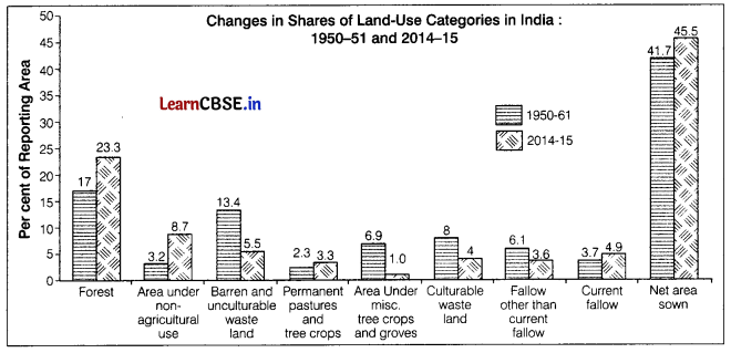
Directions Study the following graphs carefully and answer the question no. 15 to 17.
Question 15.
Which of these categories has recorded an increase in area from 1950-2015? (1)
(a) Barren land
(b) Culturable land
(c) Net sown area
(d) Fallow other than current fallow
Answer:
(c) Net sown area
![]()
Question 16.
The area under wasteland has declined due to which of the following reasons? (1)
(a) Due to increase in forests
(b) Due to conversion of land for industries
(c) Due to expansion of agriculture
(d) All of the above.
Answer:
(c) Due to expansion of agriculture
Question 17.
Which of the following categories of land use has recorded the maximum difference in his change from 1950-61 to 2014-15? (1)
(a) Area under tree crops and groves
(b) Barren and uncuhurable wasteland
(c) Current fallow
(d) Forest
Answer:
(b) Barren and uncuhurable wasteland
Section B
Section B consists of 2 Source based questions of 3 marks each
Question 18.
Read the given passage carefully and answer the questions that follow. An important aspect of population growth in India is the growth of its adolescents. At present the share of adolescents i.e., up to the age group of 10-19 years is about 20.9% (2011), among which male adolescents constitute 52.7% and female adolescents constitute 47.3%. The adolescent population, though, regarded as the youthful population having high potentials, but at the same time they are quite vulnerable if not guided and channelised properly.
There are many challenges for the society as far as these adolescents are concerned, some of which are lower age at marriage,
illiteracy – particularly female illiteracy, school dropouts, low intake of nutrients, high rate of maternal mortality of adolescent mothers, high rate of HIV and AIDS infections, physical and mental disability or retardedness, drug abuse, and alcoholism, juvenile delinquency and commitence of crimes, etc. In view of these, the Government of India has undertaken certain policies to impart proper education to the adolescent groups so that their talents are better channelised and properly utilised.
The National Youth Policy is one example which has been designed to look into the overall development of our large youth and
adolescent population. The National Youth Policy (NYP-2014) launched in February 2014 proposes a holistic ‘vision’ for the
youth of India, which is “To empower the youth of the country to achieve their full potential, and through them enable India to
find its rightful place in the community of nations”.
(i) What is the share of adolescent as per Census 2011 and what is the share of male and female? (1)
(ii) What are the challenges for the society as far as these adolescents are concerned? (1)
(iii) When was the National Youth Policy was launched? (1)
Answer:
(i) As per Census 2011, adolescent share is 52.7%, among which male adolescents constitute 52.7% and female adolescent constitute 47.3%
(ii) As far as these adolescents are concerned, the challenges for the society are lower age at marriage, illiteracy-particularly female illiteracy school dropouts, low intake of nutrients, etc.
(iii) The National Youth Policy (NYP-201 4) was launched in February 2014.
Question 19.
Observe the given map and answer the following questions.
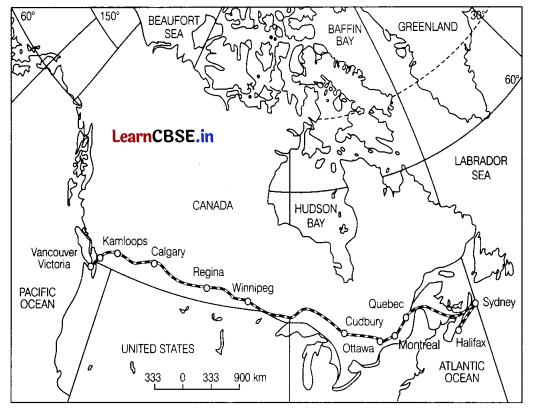
(i) Which railway line is shown in the map? (1)
(ii) Name the terminal station along the Atlantic coast. (1)
(iii) This railway is considered economic artery of North America. Why? (1)
Answer:
(i) Trans-Canadian railway line has been shown on this map.
(ii) Halifax is the terminal station along the Atlantic coast.
(iii) This railway line is considered economic artery of the country as it connects Quebec-Montreal industrial region with the wheat belt of the Prairie region and Coniferous forest region in the North. It also conect important waterways of the country.
Section C
Section C consists of 4 questions of 3 marks each
Question 20.
Define the evolution of land transport in the world. (3)
Or
Describe the Trans-Canadian railways. (3)
Answer:
Land transport includes the rail and road transports. It includes movement of people and cargo over short and long distances.
The revolution in land transport came about only after the invention of the steam engine in the 18th century. Perhaps the first public railway line was opened in 1825 between Stockton and Darlington in Northern England and then onwards, railways became the most popular and fastest form of transport in the 19th century.
It opened up continental interiors for commercial grain farming, mining, and manufacturing in USA. The invention of the internal combustion engine revolutionised road transport in terms of road quality and vehicles (moto cars and trucks) plying over them. Among the newer developments in land transportation are pipelines, ropeways, and cableways. Liquids like mineral oil, water, sludge, and slurry are transported by pipelines. The great freight carriers are the railways, ocean vessels, barges, boats and motor trucks, and pipelines.
Or
The Trans-Canadian Railways is a 7050 km long rail line in Canada which runs from Halifax in the East to Vancouver on the Pacific Coast passing through Montreal, Ottawa, Winnipeg and Calgary. It was constructed in 1886, initially as part of an agreement to make British Columbia on the West coast join the Federation of States. Later on, it gained economic significance because it connected the Quebec-Montreal Industrial Region with the wheat belt of the Prairie Region and the Coniferous Forest region in the North.
Thus, each of these regions became complementary to the other. A loop line from Winnipeg to Thunder Bay (Lake Superior) connects this rail line with one of the important waterways of the world. This line is the economic artery of Canada. Wheat and meat are the important exports on this route.
Question 21.
What is ‘basic needs approach’ to human development in the world? (3)
Answer:
The basic needs approach to human development was initially proposed by International Labour Organisation (ILO). In this approach, the question of human choices is ignored, as the main emphasis is laid on the provision of basic needs, These basic needs are the necessities that enables a person to survive and fulfil the essential requirements. There are six basic needs identified in this approach. These are as follows
- Health Proper health required to maintain a healthy lifestyle.
- Education Provision of schools and colleges.
- Food Nutritious food to fulfil daily requirements.
- Water Supply Provision of clean drinking water.
- Sanitation Proper sanitation facility to maintain hygiene.
- Housing Proper dwelling place with basic facilities.
![]()
Question 22.
Outline the distribution of inter-continental air routes across the world. (3)
Or
Discuss the emergence of satellite communication. Also, comment on the status of India’s satellite development. (1.5+1.5)
Answer:
The distribution of inter-continental air routes is
- In the Northern Hemisphere, there is a distinct East-West belt of inter-continental air routes. Dense network exists in Eastern USA, Western Europe, and South-East Asia.
- USA alone accounts for 60 percent of the airways of the world.
- New York, London, Paris, Amsterdam. Frankfurt, Rome, Moscow, Karachi. New Delhi, Mumbai, Bangkok, Singapore, Tokyo, San Francisco, Los Angeles, and Chicago are the nodal points where air routes converge or radiate to all continents.
- Africa, Asiatic part of Russia, and South America lack air services, There are limited air services between 10-35’ latitudes in the Southern Hemisphere due to sparser population, limed landmass, and economic development.
Or
Communication through satellites emerged as a new area in communication technology since the 1 970s after USA and former USSR pioneered space research. Artificial satellites, now, are successfully deployed in the Earths orbit to connect even the remote corners of the globe with limited onsite verification. These have rendered the unit cost and time of communication invariant in terms of distance, This means it costs the same to communicate over 500 km as it does over 5,000 km via satellite.
India has also made great strides in satellite development. Aryabhatta was launched on 19th April, 1975, Bhaskara-l in 1979 and Rohini in 1980. On 18th June, 1981, APPLE (Arian Passenger Payload Experiment) was launched through Arian rocket.
Bhaskar, Challenger and INSAT I-B have made long-distance communication, television and radio very effective.
Question 23.
What caused environmental pollution? Mention four types of pollution responsible for the environmental degradation. (1+2)
Answer:
Pollution of environment is caused by the release of unwanted substances from waste products of human activities. Pollution of environment is the introduction of pollutants that can cause damage to environment and harm to humans or other living species. It is the addition of an undesirable substance o form of energy to the environment at a rate faster than the environment can accommodate it by dispersion, breakdown, recycling etc. The four types of pollution which are responsible for the environmental degradation are as follows
- Water pollution
- Air pollution
- Land pollution
- Noise pollution
Section D
Section D consists of 5 questions of 5 marks each
Question 24.
What are major characteristics of road transport in India? (5)
Answer:
Characteristics of road transport in India are as follows With a total length of 548 lakh km of roads, India has placed itself among the countries which have a large road network.
Road transport carries about 85% of passenger and 70% of freight traffic every year. It is preferred for short-distance travel as it provides door-to-door service. Roads are mainly concentrated and around urban areas, rural and remote areas are least connected by the roads. Distribution of roads is not even throughout the country. Road density is highest in Kerala and lowest in Jammu and Kashmir. Most of the Northern and Southern states have highly dense network of roads as compared to NorthEast and Himalayan region.
In India, roads are classified on the basis of purpose of construction and maintenance in National Highways (NH), State Highways (SH), major district roads and rural roads. A part from above roads, there are border roads which are constructed for defence purpose and international roads which are constructed to link and connect with neighbouring countries. They are also used for strategic purposes.
Question 25.
Which are the two main ferrous minerals found in India? State any four characteristics of each. (1+4)
Or
State any two uses of manganese. Also discuss about the statewise distribution of manganese in India. (2+3)
Answer:
The two main ferrous minerals found in India are iron ore and manganese. They provide a strong base for the development of metallurgical industries.
Characteristics of Iron Ore
- The two main types of iron ore found in India are haematite and magnetite.
- India has a superior quality of iron-ore and India has the largest reserve of iron-ore in Asia
- The iron-ore mines are located in close proximity to the coal fields in the North-Eastern plateau region which is an advantage for the iron-ore industry.
- Indias 95% of the total iron-ore reserves are found in the states of Odisha, Jharkhand, Chhattisgarh, Karnataka, Goa, Andhra Pradesh and Tamil Nadu Thus, there is uneven distribution of iron-ore reserves in the country.
Characteristics of Manganese
- It is an important raw material in smelting iron-ore and manufacturing ferroalloys.
- Manganese deposits are found mainly in the Dharwar rock system, but it is found in almost all geological formations.
- The loading producer of manganese in India is Odisha. The mines are located in central part of the iron-ore belt of India, in Bonai, Keonjhar, Sundergarh. Gangpur, Balangir. etc.
- Manganese mines are located far away from steel plants which adds to the cost of transportation of the raw material to these plants.
Or
The uses of manganese are as follows
- It is used as a raw material in iron and steel industry for smelting of iron ore.
- It is used in the manufacturing of ferroalloys. Statewise distribution of manganese are as follows Manganese is found in the rocks of all geological formations in India.
- But, large manganese deposits are found in the rocks of Dharwar system.
- Odisha is the ‘largest manganese produçer in India. Central part of the iron-ore belt of India has most of the manganese mines of Odisha.
- These mines are located in the districts of Keonjhar, Sundargarh. Koraput, Kalahandi and Balangir in Odisha.
Karnataka is also known for its manganese mines. - Dharwad, Bellary, Belgaum, Uttara Kannada, Chikmagalur Shimoga, Chitradurga and Tumkur are districts having major manganese mines.
- Manganese mines of Maharashtra are situated in Bhandara, Nagpur and Ratnagiri.
- In Madhya Pradesh, most of the manganese mines are located in the belt of Balaghat, Chhindwara, Mandla and Jhabua districts.
- Other producer states of manganese are Andhra Pradesh, Goa and Jharkhand.
Question 26.
Mention three characteristics of the last stage of Demographic Transition Theory. (5)
Or
Explain the trends of population growth in the world. (5)
Answer:
This stage is characterised by a decline in fertility and mortality rates. Birth rate is nearly equal to death rate and there is little growth in population. In this period, population becomes more urbanized, literate and has high technical know how and deliberately controls the family size. It has the following characteristics
(i) There is decline in fertility and mortality rates due to advances in the field of health and educated population.
(ii) Birth rate and death rates in this stage are nearly equal. Thus, there is very less growth in population of the region. The population consists of more number of old people.
(iii) The population becomes highly urbanised, and literate and has high technical know how, The people deliberately control their family size to fulfil their own individual ambitions and due to availability of birth control measures.
Or
The world population has been growing rapidly. Following are the stages in which the world population has grown over years
(i) In early stage, the population grew at a very slow rate. Even aller agricultural revolution, the size of human population was small.
(ii) In stage II, rapid population growth started after expansion of international trade in 16th century.
(iii) In stage III, the population explosion started after Industrial Revolution in the 8th century. A series of dramatic technological changes rapidly expanded the resource base and provided a foundation for accelerated population growth that continued for more than two centuries.
![]()
Question 27.
“Dairy farming is a highly specialised and advanced primary activity”. Justify. (5)
Answer:
‘Dairy farming involves rearing of much animals wiich are used to produce milk and milk related products to be sold in the urban markets. It is highly specialised and advanced, which can be understood from the following points
- Capital Intensive It is highly capital intensive, as it requires construction of animal sheds, storage facilities, and transportation infrastructure.
- Use of Technology It involves the use of feeding and miiching machines to improve productivity and efficiency of the processes involved in extraction of milk and processing of milk products.
- Use of Scientific Techniques Scientific techniques such as cattle breeding, healthcare services and veterinary services are used in this type of activity. These services are used to prevent diseases in the milch animals and to improve the production and poductivity of milk yield. Improving the production results in diversification of products which are sold in the nearby urban and industrial markets
- Labour Intensive This type of activity is highly labour-intensive, as it requires extensive care in feeding and mulching. There is no off-season as in the case of crop production and it is practiced throughout the year due to high demand in the urban markets.
- Preservation and Storage Infrastructure Dairy products require refrigeration, pasteurisation and various other advanced preservation processes which improves the efficiency of production by improving the product’s shelf life.
Question 28.
Differentiate between primitive subsistence agriculture and Mediterranean agriculture. (5)
Or
Difference between co-operative farming and collective farming, starting five points of distinction. (5)
Answer:
The differences between primitive and Mediterranean agriculture are
| Primitive Subsistence Agriculture | Mediterranean Agriculture |
| It is an early form of agriculture, which is mainly practiced by tribes in the tropical regions. | It is a highly specialised form of commercial agriculture that is practiced in the Mediterranean regions of Europe. Africa, America, etc. |
| The tribes clear a patch of land by fire and the ashes produced makes the soil fertile It is also known as slash-and-burn agriculture. | It involves the production of a large number of crops such as olives, figs. fruits. vegetables in Large estates. |
| The production is consumed by the farmer and its family, and there is no surplus production. | The production is in surplus and it is sold in the urban and industrial regions due to their high demand Products are also meant to be exported in the international markets. |
| The cultivated patches of land is very small and it involves the use of primitive toots such as hoe and sticks. | The cultivation s done on large estates and gardens and involves specialised machines and techniques to improve thu production and productivity. |
| It is known by different names in different regions which are Jhumming in India, Milpa in Mexico and Ladang in Indonesia and Malaysia. | The specialised form of Mediterranean agriculture is known as viticulture. It involves production of high-quality grapes to produce wines. The interior grapes are dried to produce raisins and currants. |
| It is practiced in tropical regions of Africa, South America, Central America, and South-East Asia. | It is practiced in European Mediterranean region from Tunisia to Atlantic coast in Africa, South California, and Australia. |
Or
Differences between cooperative farming and collective farming are as follows
| Co-operative Farming | Collective Farming |
| Co-operative farming takes place when farmers pool their resources voluntarily for efficient and profitable farming. | Collectve farming takes place when there is social ownership of means of production. |
| In cooperative farming, farmers have individual ownership of the resources. | In collective farming, farmers pool all their resources. though they are allowed to keep very small piece of land for their own use. |
| Co-operative societies help farmers in buying farm inputs on favourable terms. | In collective farming, all farm inputs are provided by the government. |
| Co-operative societies also help the farmers in selling the farm products profitably. | In collective farming, farm products are sold to the state at a fixed price. |
| Co-operative farming has been successful in many European countries and that is why, it’s practiced in many other countries of the world. | It was introduced in erstwhile Soviet Union in order to improve the inefficiency of previous method of agriculture. |
Section E
Section E consists of 2 Map based questions of 5 marks each
Question 29.
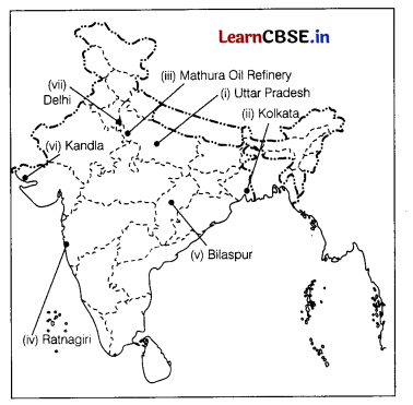
On the political map of India, locate and label any five of the following with appropriate symbols. (5)
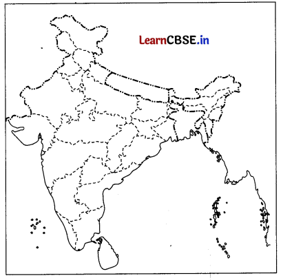
(i) Leading producer of sugarcane
(ii) An International Airport in West Bengal
(iii) Mathura oil refinery
(iv) An iron ore mine in Maharashtra
(y) A bauxite mine in Chhattisgarh
(vi) A major seaport
(vii) Largest international airport in North India.
Answer:
![]()
Question 30.
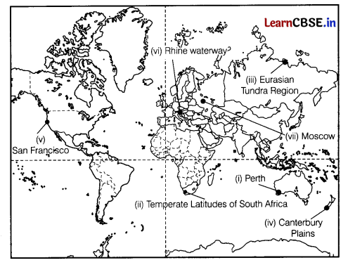
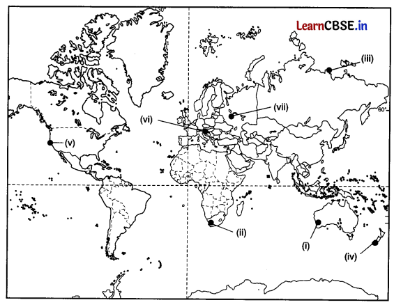
On the given political map of the world, the following seven features are shown. Identify any five of these features and write their
correct names on the lines marked near each feature. (5)
(i) Western Terminal Station of Trans-Australian Railway
(ii) A major area of mixed farming
(iii) An area of nomadic herding
(iv) An area of extensive commercial grain farming
(v) A major seaport
(vi) An inland waterway
(vii) An international airport
Answer:
